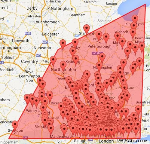
バウンディングボックスクエリ内でポリゴン内ではないポイントを削除するには、ポリゴン内のポイントを使用する必要があります。 アルゴリズム。
これを行う最も簡単な方法は、座標を配列にすることです。これらを使用して、クエリおよびpointInPolygon()関数のパラメータの最大座標と最小座標を見つけることができます。
function pointInPolygon(polySides,polyX,polyY,x,y) {
 var j = polySides-1 ;
  oddNodes = 0;
  for (i=0; i<polySides; i++) {
    if (polyY[i]<y && polyY[j]>=y  ||  polyY[j]<y && polyY[i]>=y) {
        if (polyX[i]+(y-polyY[i])/(polyY[j]-polyY[i])*(polyX[j]-polyX[i])<x)  {
            oddNodes=!oddNodes;
        }
    }
   j=i; }

  return oddNodes;
}
マップコードで、 jQuery getJSON()を使用します
var polySides = 4;//number of points in polygon
//horizontal Latitude coordinates of polygon
var polyLat = new Array();
polyLat[0] = 51.5;
polyLat[1] = 51.5;
polyLat[2] = 52.5;
polyLat[3] = 53;
polyLat[4] = 51.5;//First point repeated to close polygon
//vertical Longitude coordinates of polygon
var polyLng =  new Array();
polyLng[0] = 0.5;
polyLng[1] = -1.9;
polyLng[2] = -1;
polyLng[3] = 0.6;
polyLng[4] = 0.5;
//Coordinates for bounding box
var maxLat = Math.max.apply(null,polyLat);
var minLat = Math.min.apply(null,polyLat);
var maxLng = Math.max.apply(null,polyLng);
var minLng = Math.min.apply(null,polyLng);

//Using jQuery
var url = "yourFile .php";
 url +="?maxLat="+maxLat +"&minLat="+minLat +"&maxLng="+maxLng +"&minLng="+minLng;
 $.getJSON(url,function(data) {
    $.each(data.marker,function(i,dat){
        if (pointInPolygon(polySides,polyLat,polyLng,dat.lat,dat.lng)){
            var latlng = new google.maps.LatLng(dat.lat,dat.lng);
            addMarker(latlng,dat.name);
            bounds.extend(latlng);
        }
    });
    map.fitBounds(bounds);
});
バウンディングボックスとポリゴンの点を使用して取得したマップ。

